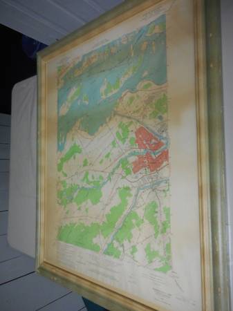
Created by the U.S. Department of the Interior Geological Survey in 1964, this vintage map displays the Massena Quadrangle of New York and Ontario. It features the towns of Massena, Norfolk, and Louisville, as well as the St. Lawrence River, and Long Sault and Croil Islands.
It is framed in a wooden frame that is 31.5" high by 25.5" wide and has a protective glass covering. There is some discoloration on the map, but it is quite readable and displays well in the distressed frame. It is ready to hang in your home and would make a wonderful holiday gift.
This vintage map comes from a smoke-free and pet-free home. If the ad is visible, the framed map is still available.